
infrastructure
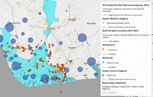
Oil Production by Field and Company, 2010
This layer displays annual production levels for crude oil, gas, and water by field and company for 2010. Map markers are scaled based on total oil production, in barrels, for 2010. Data obtained from Tables 3.1-3.11 of the 2010 Annual Statistical Bulletin (pdf) from the Nigerian National Petroleum Corporation.

Nigeria Oil Blocks
This layer shows the oil blocks that are allocated to oil companies in Nigeria. Each company can drill within a specific block.

Nigeria Gas flare Locations
This layer dipicts gas flares in Nigeria and is taken from the US National Geophysical Data Center. The data available only shows locations and not amounts flared.


